Magnum Goldcorp Fact Sheet
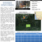
Magnum Goldcorp is developing the LH Property located on east of Slocan Lake approximately 7.0 km south of the village of Silverton, in the Slocan Mining Division of southeastern British Columbia.

The LH Property is a gold exploration property consisting of 19 contiguous crown granted claims and 7 mineral claims, located approximately 7 km south of Silverton, British Columbia, on the east side of Slocan Lake. As announced April 27, 2016, Magnum now owns 100% of the LH Property.
In 2022, the Company completed a drill program to continue evaluation of multiple high-grade, gold-bearing, pyrrhotite mineralized zones spatially associated with the LH underground workings (see News Releases dated May 30, 2022 and July 4, 2022). Gold-bearing zones have been previously documented from both underground chip sampling by a previous operator and diamond drilling by Magnum (see News Releases dated Nov. 25, 2019, Feb 8, 2018, Aug. 18, 2015).
The holes completed in 2022 continue to document multiple, pyrrhotite mineralized, variably gold-bearing zones, including high-grade, gold-bearing intervals, consistent with previous programs. Very high-grade intercepts, arbitrarily defined as those above 10 g/t Au, are comparatively small, however, they are contained within much larger mineralized intervals and, when composited over the width of those intervals, return respectable average grades over encouraging widths. Furthermore, the strong correlation between prominent magnetic anomalies and well mineralized, gold-bearing intervals has been extended to both depth and farther south, beyond immediate proximity to the LH Underground workings. More specifically, shallow intercepts in both holes LH22-55 and 56 are located approximately 160 m south of the surface trace of the underground workings.
Cumulatively, results to date document multiple high-grade, gold-bearing intervals, varying in thickness from at least 1 metre to in excess of 8.75 m thick. Sections document mineralized zones extending to at least 100 m below surface and approximately 160 m south of the underground workings. In addition, drill hole LH86-06 (drilled previously by Noranda Exploration Ltd, internal report dated 1986) documents two mineralized intervals, the first grading 1.46 g/t over 10.65 m and the second grading 1.46 g/t over 13.20 m, with the second located 150 m below surface at the eastern end of the surface projection of the LH Underground Workings.
Underground sampling confirms that variable, moderate to high-grade gold (≤154.08 g/t) has been documented throughout Levels 1 and 2, from east to west (approximately 100 m) and north to south (approximately 40 m). Drilling by the Company continues to document high-grade, gold-bearing mineralization, extending to a depth of at least 100 m below surface, with previous drill-hole LH86-06 documenting mineralization extending to a depth of at least 150 m below surface at the east end of the underground workings. Taken together, these data are interpreted to indicate strong potential to delineate a mineral resource spatially associated with the LH Underground Workings.
Previously tested pyrrhotite-bearing mineralized zones are spatially associated with prominent magnetic signatures in the immediate vicinity of the underground workings. Gold-bearing intercepts documented from within, and adjacent to, the underground workings are strongly correlated with pyrrhotite mineralization, with the intensity of pyrrhotite mineralization strongly correlated with gold content. Therefore, high intensity magnetic anomalies are interpreted to represent potential high-grade gold-bearing zones within the mineralized system and comprised the targets for the 2022 drill program. Furthermore, additional prominent, high intensity magnetic anomalies evident in the Fingland Creek drainage are interpreted to be similarly correlated with gold-bearing pyrrhotite mineralization.
There is a history of exploration in the Property area, with underground development of the former “LH mine”. Mineralization in the workings has been described as a zone 6.1 to 13.7 metres wide, striking nearly east-west and dipping north at about 55 degrees. According to the BC MINFILE database, mineralization is hosted in quartz lenses and veins 30 to 60 centimetres wide and consists of disseminated native gold, arsenopyrite, pyrite and pyrrhotite with minor chalcopyrite and native arsenic.
Previous exploration programs between 1986 – 1988 identified surface geochemical anomalies and subsequent drilling documented gold-bearing intercepts.
In 1987 surface prospecting and soil geochemistry by Noranda Mines located the Ridge Zone which they tested by eight drill holes. The property was picked up by International Bethlehem Mining Corp. (International Bethlehem) and in October 2012 the company completed a 246 metre drill program in the Ridge Zone, approximately twinning Noranda Hole LH88-23, which reported an intersection of 10.78m grading 4.38g/t Au and confirmed the presence of the Ridge Zone mineralization.
Magnum was granted an option by International Bethlehem in 2012 to acquire a 51% interest in the LH Property.
In 2014 Magnum conducted an exploration program, completing 4 helicopter supported drill holes at 2 separate locations for a total of 707 metres. The program successfully tested magnetic anomalies identified from a ground geophysical survey also completed in 2014. Coincident Self-Potential (“SP”) and Induced Potential (“IP”) anomalies are associated with the magnetic trend.
The objective of the 2014 drill program was to test the interpretation of an association between magnetic anomalies and the presence of pyrrhotite and, more importantly, associated gold. The program is considered to have been successful, with approximately 37.6% of the core returning gold values in excess of 0.1 gm/tonne and a further 5.5% returned gold values in excess of 0.5 gm/tonne.
A 2015 drill program conducted by Magnum intersected 16.9 m of 13.58 g/t Au, including 10.9 m of 20.61 g/t Au, and as well, 11 m of 20.66 g/t Au. As part of its 2015 exploration program, the Company initiated a helicopter supported drill program to target high grade gold mineralization previously identified in the LH underground workings. A total of 11 drill holes were completed from a single pad for a total of 693 metres. The objective of the program was to confirm high grade gold mineralization reported from both previous drilling and underground chip sampling by previous operators. Previous work was interpreted to suggest gold-bearing mineralized zones are associated with intervals having elevated sulphide content.
In 2016, Magnum completed the acquisition of all of the interest in the LH Property, and now owns 100% of the Property.
A ground geophysical program was conducted in 2016 comprised of a combined SP Survey, Magnetometer and Horizontal Loop EM survey. The SP Survey completed was comprised of: 1) several infill lines on the east flank of the Ridge Zone; and 2) several lines over the surface projection of the LH Property underground workings to further develop the target for future drilling.
High grade, gold-bearing mineralization is closely associated with, and interpreted to be hosted by, pyrrhotite ± arsenopyrite mineralization. As pyrrhotite is both strongly magnetic and highly conductive, the presence of pyrrhotite in the near sub-surface is expected to be easily detectable using indirect electromagnetic and magnetic geophysical methods.
A large anomalous zone has been delineated on the east flank of the Ridge, extending from Line 5 to immediately south of Line 8 (in the immediate vicinity of the “Ice Tunnel”). The defined zone, having an apparent trend of 020° – 200°, widens from approximately 75 m (north) to approximately 150 m at its southern boundary and remains open to the south. Additional moderately anomalous results are evident along, and on the east side, of Fingland Creek, east of, and below, the LH Property underground workings.
SP results from the area of the LH Property underground workings document a relatively large zone of moderately to highly anomalous values, with the maximum values occurring in the immediate vicinity of Adit 1, where a large gossan is exposed at surface and drilling intersected mineralization in the shallow sub-surface. The anomaly in the LH Property Underground area is approximately 338 m north-south x 300 m east-west. There appears to be an east-west trend, extending from the LH Property Underground Workings west toward Fingland Creek. The second zone of anomalous SP values appears to be offset approximately 135 m south, interpreted to potentially indicate another fault parallel to that previously interpreted along Fingland Creek.
The Company’s 2017 exploration program consisted of a ground geophysical survey centred over the LH Underground workings to delineate pyrrhotite-hosted, high grade gold mineralization previously identified in the LH Underground workings. A follow-up diamond drill program was conducted to further evaluate results of both the ground magnetic survey and sub-surface, high-grade gold mineralization previously identified, and associated with the underground workings of the LH Mine. Data from the magnetic survey was acquired along a series of approximately north-south oriented survey lines straddling the surface projection of the LH Underground workings. Line spacing was approximately 50 m so as to provide definition of the vein system over the entirety of its strike length.
The prominent magnetic anomaly associated with the LH Underground workings is interpreted to extend at least 150 m along strike. The magnetic anomaly spatially associated with the LH Underground workings extends east to the steep ridge defining the eastern margin of the Fingland Creek drainage basin. Two additional, sub-parallel anomalies are evident immediately south of the LH anomaly, spaced approximately 50 m apart. These are tentatively interpreted as sub-parallel mineralized trends similar to the LH system. Additional local magnetic anomalies are evident on single lines or extending over at least two adjacent lines and, therefore, approximately 30 to 100 m in strike length. There are a relatively large number of magnetic anomalies identified on the central to eastern portion of the 2017 survey grid for subsequent follow-up.
In addition, an initial comparison of the magnetic data from a 2014 magnetic survey (collected along essentially east-west lines) and the 2017 data (collected along north-south lines) defines a prominent magnetic anomaly immediately south of the 2017 survey. It appears to have a preferred east-west orientation and is tentatively interpreted as a potential fourth east-west mineralized system sub-parallel to the LH system. The two data sets will be leveled and merged for further evaluation and interpretation.
As part of its 2018 exploration program, the Company completed an airborne magnetic survey by drone to further evaluate a pyrrhotite-enriched, gold-bearing system exposed in the LH Underground workings in the upper Fingland Creek basin. The survey comprised initial acquisition of an orthophoto to determine a digital surface model (“DSM”) with which to plan and execute the subsequent magnetic survey. The previous 2017 ground magnetic survey was hindered by local, steep topography which prevented collection of critical data over the middle portion of the LH Underground workings, along Lines 7 and 8. In contrast, the airborne drone survey returned continuous magnetic data, with stations every 1.4 cm and a line spacing of 25 m, flown at a consistent elevation of 25 m above the DSM. A follow-up airborne magnetic survey (by drone) was conducted in the year to complement the survey. The drone survey confirmed, and refined, the previous 2017 ground magnetic survey, which was hindered by local, steep topography. The survey also resulted in a high-resolution magnetic survey, with continuous measurements along each flight line. Subsequent processing of this data produced a Second Vertical Derivative (“2 VD”) map of the survey area, which confirmed, and significantly refined, the magnetic signature spatially associated with the LH Underground workings. The resulting magnetic anomaly is interpreted to be sourced from a structurally controlled, pyrrhotite-enriched (and, therefore, magnetic), high grade gold-bearing system.
In 2019 Magnum completed a helicopter supported drill program to confirm high grade gold mineralization reported from both the Company’s previous drilling (see News Releases dated August 18, 2015 and February 8, 2018) and underground chip sampling by previous operators. Previous work was interpreted to suggest gold-bearing mineralized zones associated with intervals having elevated pyrrhotite (a magnetic sulphide mineral) and/or arsenopyrite.
A total of 4 short diamond drill holes were completed from a single pad for a total of 250 metres. The holes were drilled in a vertical fan to target high grade gold mineralization previously identified in the 2015 drill program, underlying the “LH Underground Workings” (see News Release dated August 18, 2015).